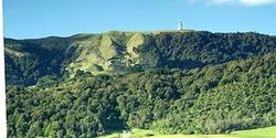
The Kaimai Range The Kaimai Range is a mountain range in the north island New Zealand. It links the Bay of Plenty to Waikato. The highest point of the range is Mount Te Aroha at 952meters above sea level. The Kaimai Range was created as the result of a fault. This fault uplifted Andesitic rocks from many extinct volcanoes. The fault has not been active for about 140,000 years ago and became active over a million years ago. |
Mount Maunganui
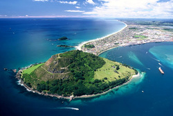
Most people know Mount Maunganui as a town in the Bay of Plenty region but it also a extinct volcano. It's Maori name is Mauao. It is located at the end of a peninsular in the town Mount Maunganui by the eastern entrance to the Tauranga harbor. It is considered very important and Tapu by the local Maori iwi. It features in the local mythology quite a bit (Below is the Legend of how Mauao got it's name.) It also has great historical value. the highest point is 232 meters above sea level and is 2.35 million years old. It is now a popular location for many activities including scenic walks, jogging and even hang gliding. |

Pyes Pa Although the Pyes Pa area is not well know to many people is has an amazing Legend behind it and has significant meaning to me.(Please read the Legend of the Pyes Pa, Below.) I went to Pyes Pa school for two years and learnt a lot about that area, I thought that this was really cool because I still live there now and understand more about it. Although there is not any information about this area, I think that is is a major part of Tauranga's Geological history. |
